Monday, August 10, 2015

Georgetown, KY

Another sunny day with the threat of showers.  Oh, well, we will make due if that happens.

Our ventures today center in Georgetown.  Georgetown 's first permanent settlers, Baptist Minister Elijah Craig and members of his flock, arrived in 1784 and incorporated the town of Lebanon.  The territory was at that time part of Virginia.  In 1790 the Virginia legislature renamed the city George town in honor of President George Washington.  It is believed that the first bourbon whiskey was made in Georgetown by Rev. Craig in 1789.  Bourbon is no longer produced in the county, however, the state remains the nation's largest whiskey producer.

Our first stop is at the Kentucky Horse Park which is a world famous equine park dedicated to sharing Kentucky's love of horses with the rest of the world.  It is a 2,224 acre park which is home to a number of horse events, an international museum of horses, a working farm, and many shows.  The grounds are beautiful but we are not into horses much so elect to walk around the outer grounds taking some of the pictures below honoring Secretariat and Man  of War.


Along the road back we pass the Old Friends Farm for Retired Thoroughbreds which is a 92 acre farm that is home to over 65 former racehorses.  The non profit retirement center was established in 2003 and cares for mostly stallions whose racing and breeding careers  have come to an end.

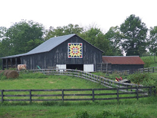
Taking another back road, we head north taking pictures along the Buffalo Gals Barn Quilt Trail where we find many barns with wood quilt block designs attached to the barns.  Each quilt pattern is unique.  We have seen this in a couple of other states, but never driven the roads until today.  Below are a number of the barns we photographed.  


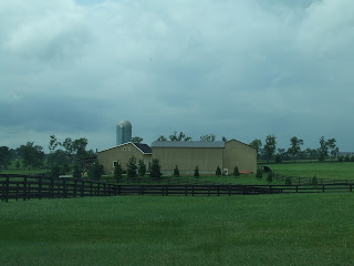
So much of the back roads lead you past what I typically associate with Kentucky and horse raising shown below.  It really is beautiful countryside with wooden fences, lots of green grass and beautiful homes and barns.


Many of the barns in this area are worth more than a million dollars such as the one below.

Just out of town and on our way downtown is this beautiful old national landmark home, Ward Hall, built in 1853 and believed to be the largest Greek Revival house in Kentucky.  Unfortunately they only do tours on the weekend.


We finished our day today taking pictures of some of the beautiful large old homes along the Main Street of Georgetown and walking the historic downtown streets taking more pictures of the interesting buildings.  We never seem to get enough of these old buildings.  They are all so different and yet the same.

This is the old Scott County Jail


Note the quilt blocks on the railing and side of the building

Old City Hall

Note the date on the building below.


Frankfort, KY

Sunday, August 9, 2015

We have spent the past couple of days just relaxing in the RV and enjoying not doing anything.   Being on the go so much this summer was nice but  just sitting and relaxing is nice too.  The campground we are in here in Georgetown, KY is located just out of town on several acres and our site overlooks a pond and a local farm with house and barn.  It is a very popular and busy campground and was almost full every night especially over this past weekend. We will be here until next Thursday when we  move on to Tennessee for one night before heading into Arkansas for about a week.


Today we take a drive to Frankfort, KY which is the state capital and about 20 miles from here.  Frankfort has been the state's seat of government since 1792.  The city's north and south sections are separated not only by water but also by their historical backgrounds and architectural styles.  The north section originated around 1786 while the south was developed after the new capitol was built in 1910.

Taking a local highway takes us through some beautiful countryside with large farms and some lovely large homes on numerous acres. Along the way we see a sign for an old covered bridge in the town of Switzer.


The bridge was built in 1855 by Geroge Hockensmith and restored in 1906 by Louis Bower and spans the North Fork of the Elkhorn Creek.   The bridge stands 12 feet high and 120 feet long.  In 1997 it was damaged but rebuilt in 1998.   Unfortunately it has been marred by graffiti.  The bridge was not on our list of attractions, but taking back roads often leads you to these interesting sights.

While driving down another road in the old part of Frankfort we discover an old Civil War fort called Fort Hill which is located up several very steep hills and down some very, very narrow residential streets.  The Visitor Center building (Sullivan Inn and Tavern which was moved here from somewhere else) in the park is closed today but we are able to find a few signs to tell us about the battle that took place here.\


"There are two Civil War earthworks in the park -- Fort Boone and the New Redoubt. A detachment of John Hunt Morgan's raiders attacked Fort Boone on June 10-11, 1864, but a group of local militiamen fought off that raid from behind the walls of the fort. The New Redoubt was built by Union Army engineers as a replacement for the state-designed Fort Boone. Ironically, the Fort Hill earthworks are Union fortifications built in part by slave labor -- slavery remaining legal and commonplace in Kentucky until the ratification of the 13th Amendment to the U.S. Constitution. Men of the 103rd Ohio Volunteer Infantry did much of the work on Fort Boone."

Back on the main road is a sign for a Kentucky River Dam which we follow through some old, old residential neighborhoods to the Dam now abandoned.  The buildings here are very old and dilapitated.  In 1978 there was a flood here with water 48 feet above the river below.  Hard to believe it rose that high.


We also drive through historic Frankfort downtown which today is mostly closed up allowing us to see more than we would during the week.

Back on the road to Georgetown we pass this Jim Beam plant and find some 18 wheel tankers with the Ballard name on them.  We had hoped they did tours here, but they only do them in Lexington.  There is a Distillery in Frankfort which we will tour another day.


Further along the road we come to this old Catholic Church originally built in 1794 with the current structure built in 1820.  St. Francis Mission is the second oldest Catholic Church west of the Alleghenies.


One of the things we have noticed on our travels here in Kentucky are the many, many rock walls surrounding properties with a very unique top on them consisting of flat stones similar to slate placed on their sides vertically all along the top such as the one here.  What we learn is that there is no mortar between the rocks.  These fences are called dry stone fences and they relied on stonemasons for their stability.  The majority of these fences were built in the late to mid 19th century by Irish stonemasons.  During the 1990's it was realized that only a few of these fences in poor condition were still standing.  The Dry Stone Masonry Conservancy was formed to preserve and continue the art of dry stone masonry.  Interesting and different.


Traveling certainly allows you to see so many different things and to learn more about our country and its history, customs in different states and see some beautiful countryside.  I would not trade this time in the RV for anything.

Wednesday, August 5, 2015

Last Day in Gettysburg and on to West Virginia

Monday, August 3, 2015

Today is our last day in Gettysburg so we head out to take some photographs at a couple of towns close by. All of these towns have round abouts in the center of their historic downtowns and some interesting pre Civil War buildings as well as houses.

In New Oxford we drive around the round about where we see a number of old buildings and  find this old railroad station a few blocks away.  


In Abbottstown, we find this old City Hall in the round about  which is being renovated as evidenced by the scaffolding.


In Hanover, we find this old church with the tallest spire that I have ever seen.  I could not even get this entire building and spire in one picture standing across the rather narrow street.  One of the things that  cannot be avoided in pictures in these old towns are all the overhead electrical lines.


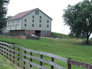
One of our fascinations here in Pennsylvania has been with the old, old barns.  These are the Pennyslvania Barns which are rather unique to this state.  These barns appeared in the late 1800's and flourished from 1820 to about 1900.  They are most prevalent in the southeast and central parts of Pennsylvania and were most common among the Pennsylvania Germans.

The Pennsylvania Barn features a 7-8 foot forebay or overshoot and is banked on one side.  The upper levels consisted of a threshing floor, flanked by mows (an area in the barn where hay, grain or other feed is stored) and a granary which was sometimes located in the forebay and sometimes next to the mow on the bank side.  The building sported a gable roof.  The lower level is a stable or stalls for horses, milk cows, beef cattle and sometimes hogs or sheep with alleyways between humans.  The barns range in size from 20 feet to over 100 feet long.

Below are a couple of old barns which we came across as well as this updated version.


On our way back to Gettysburg, we came upon this old church and cemetery.  While the church has a cornerstone from 1922, a sign (see below) tells us that an old church dating to the 1700's was here and this cemetery tells us that burials date back to the late 1700's and early 1800's.   These are earlier burials than any we have seen on our trip thus far.  We have seen many Civil War cemeteries both Union and Confederate but most date from the mid to late 1800's.


A stop at the grocery store on our return to town finishes off our day.  We have enjoyed our time here and wish we had more time to take in some of the other outlying towns, but that will have to wait for another time.

Tuesday, August 4, 2015

We are off about 10:00 this a.m. for West Virginia with a trip across the very upper part of Maryland.  Driving south on Highway 15 to the town of Thurmont, we decide to take the local highway to I-7.  By the time we see the  sign that says no trucks over 40 feet on this road, it is too late for us to turn back as this is a narrow two lane road with no shoulder.  We trudge on taking all the curves and closed in treed lined areas in stride and with Ron slowing our speed to almost nothing at times as we make our way across the 20 miles to Smithburg where a road number does not jive with my map.  After driving on a short distance, we turn around at the local high school finding a kind gentleman to ask about getting to I-70.  He gives me directions and taking pity on us leads us back to the right turnoff and down a 5 mile road to the Interstate.

Getting on the Interstate, we begin following this road up and down hill and dale through many, many small towns along the way.

We also see this old car on the Interstate.


Finally nearing Morgantown where we get off and follow directions from the Interstate to the campground which is only about 2.5 miles away.  Once off the first road, we drive for 2.2 miles on a narrow (barely one lane wide) road for 2.2 miles praying that we do not encounter another RV as there is no way we could pass each other.  There was barely room for a car to pass us on this stretch.

Our campground is located among the trees and we are pointed down a narrow dirt road to our spot which is between two trees.  Carefully guiding Ron into the site, we try to find the most level spot and back up a bit so we can open our slides.  (See photo).

After getting settled in, we take off to see the town of Morgantown about 15 miles down the road.  It is a college town of some size with tall mountain on one side and river on the other giving one the feeling of being closed in.  The streets up from the river reminded Ron and I of San Francisco and Lead, SD.  Nothing really grabbed us so we turned around to begin our way back to the campground.

After getting off the Interstate at our exit, we found a sign for the Copper Rock Overlook about three miles away so decided to see what it was all about.  It was an interesting and pretty overlook.   The overlook is a free standing rock cliff formation about 50 feet from the cliff and reached by a wood bridge that was built by the forest service.


Returning to our campground, we met another couple also staying in the campground with a Blue Bird RV which we had never seen before.  We passed a pleasant evening talking with them and searching for some ice cream at another nearby campground.  It is always fun meeting other RVers and exchanging information.

Wednesday, August 5, 2015

Leaving our campground this morning we return to the Interstate to continue south toward Charleston, WV.  I am on the phone early trying to find a campground as the Elks Lodge rv facility in Charleston was full. West Virginia has few campgrounds and many do not take large RV's.  Fortunately, we were able to find a KOA south of Charleston that was  not full.

Today's scenery was much as yesterday.  This is another pretty state with its many small towns, large valleys and high bridges that gap the mountains and/or valleys.


Sunday, August 2, 2015

The Amish Country

Yesterday for another down day doing wash and planning our trip from here back to Albuquerque.

Today we took the highway to Lancaster which is the heart of the Pennsylvania Dutch Country.  This part of Pennsylvania was settled in the Colonial years primarily by religious groups of German descent seeking religious freedom.  The customs and convictions of these people have been retained today and are reflected in their dress, their work and the ways in which they spend their leisure time.  Simplicity and singular speech are but two characteristics of these people.

The road took us through a number of small and larger towns crossing the Susquehanna River to Lancaster.
During the Revolutionary War Lancaster was the largest inland city in the Colonies.  It was the capital of the nation for 1 day on September 27, 1777 as Congress fled Philadelphia after the Battle of Brandywine.    It was the state capital from 1799-1812.  The city is in the heart of Lancaster County and is known for its Amish and Mennonite populations and picturesque farmland.


Here in Lancaster we departed the main road for the scenic roads leading us through the towns of Smoketown, Bird in Hand and Intercourse (The Intercourse name came from either the entrance to the racecourse (the Entercourse) just outside the town or from the joining or intercourse of the Old Kings Highway and the Wilmington-Erie Road.)  Thought you might like to know that the name was not what you thought.  We then take the back roads to Strasburg where we head back to Gettysburg.

All the towns we go through seem alike and yet different.  All contain some very old pre Civil War homes over 160 years old and others built around the early 1900's and after. Taking pictures of just a few houses really does not do this justice.  It is hard to describe but each is alike and different.  Some are free standing, some are attached like townhouses and some have acreage around them.  Some have large porches, some have turrets, some have bay windows, some are small and some are quite large.  For the most part they are well kept up, but some definitely need some attention.

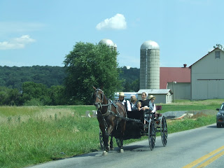
What is different in the Amish country is seeing the Amish either walking, riding scooter type vehicles or driving many different types and sizes of horse drawn open and closed carriages.  Today being Sunday, the Amish were not in the fields, but rather driving their vehicles along the highways and farm roads.  Obviously the horses are well used to cars as none seemed to be the least bit disturbed by the noises and fast speed.


The farmland here is truly picturesque and beautiful with lots of corn and other crops, very green and  lush.  We saw many farms with very large horses which we know are used by the Amish farmers to plant and tend their crops.


We stop in Bird in Hand at this antique store which Ron thought was interesting especially the old gas pumps out in front.  The store was just one of several where we stopped.


Tomorrow we will return to this Old Barn Antique Store which was closed when we passed it on our return to Gettysburg.  There are also several others that I want to explore before we leave this area.


Please excuse some of the pictures which may seem foggy as they were taken from behind the windows in the car as we drove by.