Saturday, June 18, 2016

Minidoka National Historic Site

 Friday, June 18, 2016

Yesterday I mentioned that we had learned that there was an old Japanese Internment Camp just to the east of the town of Jerome.  So today we took a drive out to see what was there. 

Many years ago I read the book called “Manzanar” which is the name of a camp located in the California Mohave desert.  As it turned out, I worked at that time for a Japanese lady in Los Alamos who was born at one of these camps.  As a result I have always wanted to visit one of these camps to learn more about the lives these “American Citizens” and aliens were forced to endure as a result of their incarceration.  I know that my boss had some real resentment even though she was but a baby when her family left their camp.  After what I have seen and read, I can hardly blame these people for their feelings.  

My parents lived in San Francisco during the War, but I don’t ever recall hearing any comments made in our family about the Japanese people at this time even though there were many, many of them living in California at that time.  I realize that I was not old enough during the War to know about the “fears and prejudice” people had during that time, but I find it appalling today to think what our country forced these American Citizens to endure.


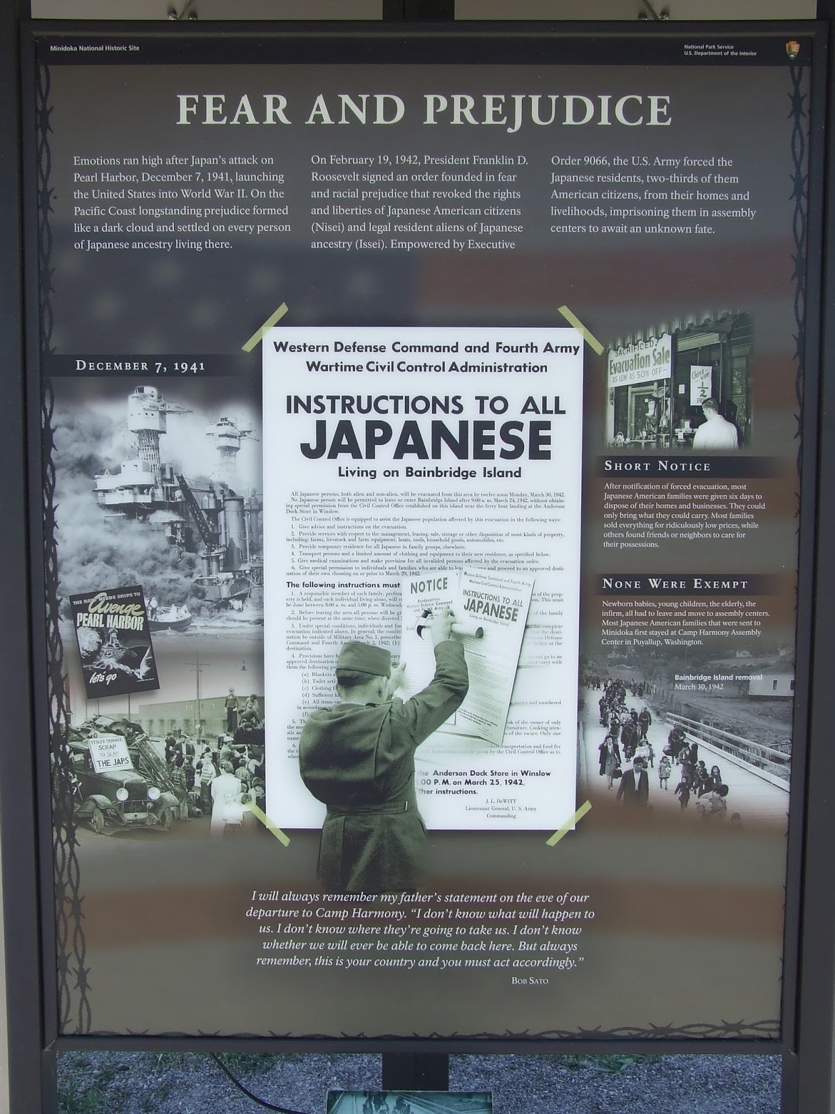
In February 1942, President Franklin Roosevelt signed Executive Order 9066 which deprived 110,000 people of their freedom.  All were of Japanese ancestry with 2/3 American citizens and half children.  These “citizens” were required to close their businesses, shut down their farms, and pack their suitcases to board trains and buses to be taken first to detention centers and later to prisons.  For the remainder of the War they would lead bleak lives while remaining behind barbed wire far from their previous homes.   There were 10 such Camps all in the Western half of the U.S.  

This site here in Idaho is today called Minidoka National Historic Site and is located 10 miles out of the closest town and at the time of the internment was nothing but dry arid land; however, having a canal running through the area provided solace for these people from the Northwest part of the country (Oregon and Washington) where water was a part of their life.  


Sign found on Highway leading to the Camp
Canal running within the Camp property
13,000 people were imprisoned with a peak population in 1943 of 9,397.  While the eight guard towers at Minidoka were never completed or manned, barbed wire did surround the area giving the residents the feeling of prison. 


Right - recreated guard tower

Upper Left - Part of Military Police Building
Bottom - Guard Tower never completed or manned
Right - Reception Center 
This camp, like many others like it, were not completed when the families arrive and buildings consisted of 600 tar paper barracks crowded into 946 acres with thin walls that were not weather proof at a time when the weather was becoming the least inclement (winter was coming on).  More barracks, furniture and other necessities were soon built by the residents along with mess halls and other buildings.  The residents helped with a farm labor crisis in the area by planting and harvesting as well as planting crops within the facility to make it self sufficient.   


An Outline of the Camp Buildings
After the War, 19,000 Japanese American soldiers were awarded the Congressional Gold Medal, many of whom had families living in these relocation camps.  Here at Minidoka, a Honor Roll plaque was erected with the names of the soldiers from Minidoka who served in many different branches of the military.  A lovely garden once stood in front of this plaque.  


Honor Roll Plaque
In 1945 a Supreme Court decision said that U.S. citizens could no longer be confined.  Minidoka closed on October 28, 1945 becoming a large ghost town as residents returned to their former homes, to different communities and rebuilt their lives and/or began new lives outside the confines of the Camp.  Many never talked about their time in these camps but as the years have passed many have opened up about their experiences.

Today this Minidoka has a building in the process of restoration for a Visitor Center.  The grounds are now a National Historic Site and there are many plaques, etc. telling the story about the Site and reminding us what can happen when other factors supercede the constitutional rights guaranteed to all citizens and aliens living in this country. Below are some of the buildings still in existence on the property. 


Picture of Warehouse Bldg. and Foundation of Such

Barracks Building

Left - Motor Repair & Tire Repair Building
Right - Storage Building

Top Left - Fire Station and Hermann House
Top Right - Barracks Buildings
Bottom - Baseball Field
A quote from President Franklin D. Roosevelt in 1943 sums it all up for me. “Americanism is a matter of mind and heart.  Americanism is not, and never was, a matter of race and ancestry.”   Let us not forget this as we go forth with our lives today.

Signing off until tomorrow's activities

Friday, June 17, 2016

Shoshone Falls and Cities to the North

Wednesday, June 15, 2016

Today we did a bit of backtracking heading 40 miles east from Twin Falls to take in the small town of Rupert, Idaho which was established in 1906.


Our information said that they had a very historic downtown which piqued our interest.  While we have seen many more interesting places, we did come upon the Wilson Theater on the historic town square that was built in 1920 and was the dream of a couple named Daniel Ward and Mennie Wilson who envisioned a beautiful and unique opera house.  The theater opened on August 25, 1920 and quickly became part of the Haris-Voeller Theater chain.
Wilson Theater 1920


It became listed on the National Register of Historic Places in the late 1990’s.  During its early history, the theater played host to vaudeville, musical performances and movies. 


Across the street from the theater I spied The Gathering Place which looked to be a quilt shop.  Entering the shop, I was completely surprised to find room after room of fabric, notions, quilts, etc.  Come to find out this is Idaho’s largest quilt shop with 14,000 (yes, that is the right number) bolts of fabric in every color and design you can imagine.  I could have spent all day in the shop but Ron was waiting in the car so I made a quick selection of fabric to go with some I bought in Salt Lake and quickly exited.  I wish I lived closer so I could return time again to this shop.  What a fabulous place.


Turning back toward Twin Falls, we make an interesting side trip to the town of Hansen to see Rock Creek Station (the first trading post along the Oregon Trail) and Stricker House. The Museum “covers the story of the Rock Creek areas from prehistoric times through the development of irrigation in the area with special emphasis on transportation themes and the story of the Herman and Lucy Stricker family who settled there in the 1870’s.”South Central Idaho became a major thoroughfare for emigrants on the way to Oregon between 1840 and 1860.  Rock Creek was just one of many stations along the way.


Across the road and up a path is the Stricker House which the caretaker opened for us explaining that there are two front doors to the house.  There is a private parlor and to the back of the room was the master bedroom of the house.  Entering through the main front door was the front room and to the far right was a bedroom behind which is the butlers pantry.  To the back of the room was the dining room and kitchen furnished with a table that sat 10 people and built in cabinet for dishes and linens.  The room was quite large and had large windows overlooking the yard beyond.  The stairway from the parlor area had very steep steps and was curved at the top.  Upstairs were 5 bedrooms each furnished with period furniture, bedding and clothing of the period.  The house was built around 1901 after a fire destroyed the original house.  All the woodwork in the home is made of ash and in the style seen in most homes of the same period.

Thursday, June 16, 2016

Our first stop today was to the Shoshone Falls in Twin Falls located on the Snake River.  The Falls are called the Niagara Falls of the West as they tumble 212 feet to the canyon floor – more than 50 feet further than the famous falls on the New York-Ontario border.  The forces that created this area are eroded basalt cliffs which are relics of the Bonneville Flood, “a catastrophic torrent that ripped through the canyon about 15,000 years ago.”  (Boy, is that a long time ago.)  In  932 Richard J. and Martha Stone Adams donated the Shoshone Falls park to the city of Twin Falls with the stipulations that the land be maintained as a public park and for the benefit and use of all people.  The Falls are truly beautiful and take your breath away.  The best time to see them is in the spring as the water is diverted later in the year to produce hydroelectric power and irrigate Idaho’s very fertile farmlands. 


Looking west down the Snake River
In 1974 Daredevil Evel Knievel attempted to jump the Snake River Canyon near the Falls in a rocket powered “motorcycle”.  Today the only evidence of that event is the dirt ramp which can only be seen from a distance.

Leaving the Falls area, we head north to the small town of Shoshone, a town which had long been considered the main railroad station in the Idaho Magic Valley region.  (More about the name “Magic Valley” later on.)  Apparently Twin Falls never developed a strong railroad presence due to the logistics presented by its location south of the Snake River Canyon.  For many years, Shoshone was the only Amtrak stop in this part of Idaho.

The town of Shoshone can be found with the railroad tracks dividing the main street of town.
Painted Mural on Side of Building                                                  Railroad Station

An old hotel and

Old Hotel
some old stores  are what constitute the main part of this old community.

On a back street we come across an old Masonic Hall as well as a couple of old homes and a quaint church.

Old Masonic Hall and side of building.  Note the unevenness of the bricks.


Turning back toward Twin Falls, we stop in the town of Jerome where we find a small town Museum and learn about the Japanese Internment Camp (Minidoka Relocation Center) which was located about 17 miles to the east.  We will travel to the site another day.  

For the benefit of those who want to know where the name “Magic Valley” came from (including me), here is the info from the internet.  The name "Magic Valley" is a reference to the construction of Milner and Minidoka Dams and a series of irrigation canal systems on the Snake River during the first decade of the 20th century. In a short time these projects "magically" transformed what had been considered a nearly uninhabitable area into some of the most productive farmland in the northwestern U.S. Many cities and towns in the region were founded between 1900 and 1910 as a direct result of these projects.”

Signing Off Until tomorrow in Twin Falls


Wednesday, June 15, 2016

Sightseeing around Twin Falls Area

Monday, June 13, 2016

Idaho greets us with a couple of rain showers though nothing that lasted very long, thank goodness.  Of course, we cannot travel far without running into a number of construction projects along the way, but nothing that delays us.  When you travel in the northern section of the U.S., you find there are only two seasons, winter and construction.


Our plan here is to take in the areas surrounding Twin Falls that we did not see on our last visit some years ago.  Twin Falls is the center of 500,000 acres of prime farmland irrigated by the water of the Snake River.  It is on the edge of the Snake River Canyon which was gorged out some 30,000 years ago by the Great Bonneville Flood. 

We are staying at the Twin Falls County Fairgrounds located in Filer, ID just a short distance to the west of Twin Falls.  It is a fairly large fairground with lots and lots of camp sites both pull through and back in all on grass and some under large tall trees.  We are told to select whatever site we like within a certain area and we find a nice site under the trees.
Weather here today is in the low 80’s and expected to drop to the high 60’s’s in the next few days with warmer temps later in the week.  That’s okay by us as temps in Albuquerque have been in the high 90’s.


Tuesday, June 14, 2016

Today we take a drive west from the Fairgrounds to the town of Buhl, a small, but very rural community.  The area here is very fertile and very agricultural where barley, alfalfa, sugar beets, barley, corn, and potatoes, to name a few crops, are grown.  It reminds us of the farming we saw in Saskatchewan, Canada when we were there.   Buhl is said to be the rainbow trout capital of the United States as the town is a leader in trout research and production.  Trout are raised and shipped throughout the world. 

After stopping at the Chamber of Commerce (Visitor Center) for some maps (apparently Buhl is not known for putting up many signs to their local attractions), we travel down one back country road to another passing farm after farm wondering all the time if we are on the right roads and will ever get to the Niagara Springs and Crystal Springs Parks.  Along the way, we come across this view from the cliffs.

When we do, we are rewarded with high up cascades of water coming out of the side of the canyon creating beautiful waterfalls emptying into the Snake River far below.  What a beautiful sight.  


We even found this little fellow floating in one of the ponds.


Another attraction in the area is Balanced Rock located 17 miles out of Buhl.  One would never guess there was a rocky area nearby.  After passing through some rocky mountains and dropping down and then up, we arrive at the Salmon Falls Creek Canyon and a unique geological formation known as Balanced Rock.  The rock is over 48 feet tall and weighs 40 tons.  The wind carved rock which looks like a question mark sits atop a pedestal of only 30 by 17 inches.  Hope no one is here when the rock decides to fall.


Looks like a Question Mark


Returning to Buhl, we continue further west high above the Snake River to one of many RV Resorts located next to the river.  The Thousand Springs RV Resort sits next to the river with these views across the way.   These springs are believed to be the reappearance of the Lost River, which vanishes into the lava fields 90 miles away.


Traveling on to the town of Hagerman, we stop to see this little park which has these sculptures honoring the impact that sheep had in this area starting during the Civil War.


An early sheepherders RV


Before returning to our campground, we stop by the local Elks Lodge which sits next to a lovely golf course.  It was a breezy and chilly day to be out golfing but we know those crazy golfers play no matter the weather.  In 2012 we made a visit to this Lodge and found the people just as friendly as before.  A drink and the Tuesday night tacos ended our day, but we will return on Friday for another drink and their steak dinner.


Signing off until the next installment from Twin Falls.         

Monday, June 13, 2016

Salt Lake City and Vicinity

We had an uneventful trip from Moab to Salt Lake City, actually Draper, UT which is where the campground we stay in is located.  My brother Gil and wife Sherry live in Sandy which is about 15 miles south of Salt Lake and just four miles from the campground.  Very convenient for them and us.

We remained here for the week enjoying time with my family as well as Sherry’s father Dick and brother Cory.  Also got our dog fix as they have a German Shepherd named Indy who enjoys lots of attention. 

There was some excitement on Tuesday when Sherry’s brother had to be rescued by from his condo by the fire department.  There was a fire in the condo next door to his with considerable smoke damage in his.  He was unable to leave the building through his door so was rescued from the third floor by ladder.  We are so thankful he was uninjured though he will be out of his apartment for at least three months while repairs, etc. are done.  Fortunately, Sherry and Cory’s Dad lives near by and Cory will move in with him until repairs are completed.  Cory even made the local news. 

In addition, we spent time one evening up in the local mountain area near by enjoying the coolness and open air as well as time with Gil and Sherry’s friends Steve and Sandy who are also RVers like us though not full time.  Always enjoy spending time with them and look forward to meeting up with them in our RV’s in the next year.  We had fun playing "Catch Phrase" that evening with ladies against the guys. 

My friend Sally from Albuquerque has a sister in the area so we enjoyed a short visit with her. as well.    I have known her for many years with both of us now breast cancer survivors.  She was a great support while I recently underwent my treatments.  Thanks, Annette.  May we both continue in good health for many more years to come.

Gil builds wood furniture so we had him repair the step stool he made for us many years ago as well as a minor wood repair in the RV.  Since we travel in the RV full time, we do not have all the tools, paints, etc. to make those types of repairs.  Sure is great to have such a talented brother.

The guys played golf on Thursday while Sherry, Sandy and I enjoyed a visit to two beautiful quilt shops with Sandy and I returning on Saturday for their Show and Tell with a coupon for a of 25% off the total purchase.  Such a deal!  Like I needed any more patterns or fabric. 

We left Draper today after saying goodbye to Gil and Sherry on Sunday as they left for two weeks on a Viking Cruise from Amsterdam to Budapest.  We will look forward to getting postcards and pictures of their trip. 

Sightseeing on this leg of our trip was put aside as we wanted to spend time with the family and we have been here many, many times over the years so have seen most of the local sites.  No time either for a visit to the LDS Genealogy Library.  That too will wait for another time; however, I have included a couple of shots taken from the RV today as we head to Idaho via I-15 and I-84.


Signing off until we reach the Twin Falls, Idaho Area.

Saturday, June 4, 2016

Moab, Utah

Our journey on Friday was from Farmington, NM to Moab, UT via Cortez, CO.  The highway takes us through Shiprock, NM with the famous rock formation from which the town gets its name.  This area is also the Four Corners where Utah, Arizona, New Mexico and Colorado all come together. 


One of the sites we see along the highway are the tops of the mountains in the distance still covered in snow.  They have had some late snow in the area this year.


After driving through Monticello, we begin a climb through some low mountain areas with beautiful views of the sandstone cliffs.   It is interesting what wind and weather have done to the various formations. 


Here too along Highway 191 is a place called “Hole N’ the Rock” which is a 5,000 square foot, 14 room home carved out of rock by Albert Christensen and completed by high wife and children after his passing.  “It began as a small alcove for the Christensen boys to sleep in at night and grew into a man-made engineering marvel 20 years in the marking”.   There is also a 65 foot chimney and a deep bathtub built into the rock.  Some original furnishings as well as Albert’s painting and tools used to create the home can be found along the 12 minute tour.


Moab is the home of Arches National Monument and Canyonlands National Park as well as Dead Horse State Park.  It is very much a tourist city and resides along the Colorado River where rafting, jeep and ATV tours and hiking abound.  If you don’t have a weekend reservation at a hotel, lodge or RV park ahead of time, you will be hard pressed to find one upon arriving on a weekend.   Here we are in our site at the Spanish Trail RV Park just south of the city of Moab and below some of the rocky cliffs.  Notice that the "little black cloud" from last summer is not with us so far this year.


Today Ron and I ventured off to Canyonlands and Dead Horse Point.  It is a 25 minute drive from Moab along the highway and then onto a wide two lane and sometimes windy and upward climbing roadway to the Parks.  Along the way there are many overlook points with what I can only say are awe inspiring scenic vistas in the distance.  One video we watched today described the area as more beautiful than the Grand Canyon.  It is amazing how deep the gorges are and how the Green and Colorado Rivers wind through the rock formations. 

Canyonlands is actually three different areas with Island in the Sky to the north (where we went) the most accessible, The Maze to the west and The Needles on the east. Water, wind, gravity and the weather were and are this land’s architect with flat layers of sedimentary rock cut into hundreds of canyons, mesas, buttes, arches and spires.  At the center are two canyons carved by the Green and Colorado Rivers.   
Monitor and Merrimac Formations


Dead Horse Point
Dead Horse State Park is located along the same route and towers 2,000 feet above the Colorado River with breathtaking panorama views of pinnacles and buttes.  According to legend, the point was once used as a corral for wild mustangs roaming the mesa.  Cowboys rounded up these horses herded them across the narrow neck of land into the point.  They then separated out the ones these wished to keep and fenced off the remainder of the horses with branches and brush leaving them on the waterless point to die of thirst with a view of the Colorado River below.    How inhumane can you be!  

While we have been to Arches National Park before, we did not do so this time.  However, I am putting in a couple of pictures from a previous visit for you to get a feel for the beauty and formations of this area as well as the others. 


We returned back to town to stop at the Moab Brewery for a bit of locally made beer and our dinner.  While I am not a great beer connoisseur, I had found their light pilsner beer to my taste last time we stopped.  Cold beer on a hot summer day sure does taste good.


Signing off until we arrive at our next destination – Salt Lake City Area
Thursday, June 2, 2016

On the Road Again

Today is the beginning of our summer travels from Albuquerque to the north (Idaho and Montana) with travels through Utah, South Dakota and Colorado before returning to New Mexico in September.   This trip has been a long time coming (9 months to be exact) and we are so happy to once again be on the road.

Tonight we are staying at the San Juan County Fairgrounds in Farmington and will leave in the morning for Moab, UT where we plan to spend two nights.  Signing off until next time.